The SharedStreets Referencing System is a non-proprietary system for describing streets and locations to allow porting of data between differing basemaps, such as a commercial GIS, a city-managed GIS, and OpenStreetMap.
As shown below, differing basemaps often do not align, making it difficult to combine data from different sources. The SharedStreets Referencing System provides a common framework to solve this problem.
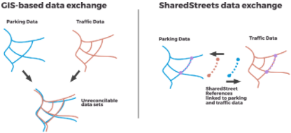
Organizations using the SharedStreets Referencing System 1 maintain their own basemaps and can share the non-proprietary information in their GIS. The system provides a stable, non-proprietary, basemap independent identifiers for identifying street segments, intersections, and geometries. Data is exchanged using these common identifiers. The types of data that might be exchanged or combined includes traffic data, street and curb inventories (CurbLR makes use of the SharedStreets Referencing System), incident reporting, and road closure reporting.
Two additional resources include:
- Getting Started with the SharedStreets Referencing System 2 – An article providing a walk-through of how the SharedStreets Referencing System works, with an example.
- A Powerful Map Promises to Help Cities Keep Streets Free 3 – An article in Bloomberg CityLab explaining the value of the SharedStreets Referencing System.
- 1SharedStreets. (n.d.). SharedStreets Referencing System. Retrieved January 28, 2021, from github: https://github.com/sharedstreets/sharedstreets-ref-system
- 2 Getting Started with the SharedStreets Referencing System, Emily Eros, https://www.sharedstreets.io/getting-started-with-the-sharedstreets-referencing-system/, May 2019.
- 3A Powerful Map Promises to Help Cities Keep Streets Free, Laura Bliss, https://www.bloomberg.com/news/articles/2018-02-22/a-powerful-map-to-share-city-streets-with-uber-and-lyft, February 22, 2018.
- Log in to post comments